These are the basic directions for a series of puzzle caches. All of the caches will use similar numbered grids for puzzles, and the same process for determining the final location. But different types of puzzles to be solved will be overlaid onto the grids (crossword-style, suduko, chess puzzles, word search, etc).
PLEASE NOTE: Due to the nature of the puzzles, and the way the reference locations are created, the Ground Zero point from the solution could be slightly off from the actual cache location. I will try to keep them within 20 feet or so, and will provide some clues if needed to get you closer.
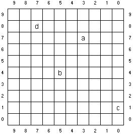
Each cache puzzle will consist of one or more 10x10 grids. Each row of a grid is numbered from 0 to 9, going from bottom to top, and each column is numbered from 0 to 9, going from right to left (see example grid below). Your goal will be to find four solution cells (labelled a,b,c,d in the example) in the grid(s). The Row,Column numbers for each solution cell will provide the values to substitute into formulas [aR].[bR][cR][dR] and [aC].[bC][cC][dC]. These values will then be added to the latitude (N-S) and longitude (W-E) of the coordinate location provided to come up with the actual location.
For the example grid below, assume that the location provided is:
+38° 37.000, -121° 12.000.
The values from the solution cells would be as follows:
aR,aC = 7,3
bR,bC = 4,5
cR,cC = 1,0
dR,dC = 8,7
[aR].[bR][cR][dR] = 7.418, which would be added to 37.000, giving 44.418.
[aC].[bC][cC][dC] = 3.507, which would be added to 12.000, giving 15.507.
So the final coordinates for the cache would be:
+38° 44.418, -121° 15.507.
BUT, the original puzzle(s) will help you locate the four solution cells, but will not specify the correct abcd order. There will be an additional puzzle, riddle, etc. to order them properly. In some cases, such as chess and suduko, portions of the grid may not be used, as it will need to be reduced to 9x9 or 8x8 dimensions.
If you are more of a visual, map-oriented person, you could think of the grid containing the “a” cell as representing a square geographic area of 10x10 minutes of lat/long, with the original location provided being the lower right corner of the grid. Cell “a” would then represent the 1x1 minute location containing the cache. The grid containing “b” would be “zooming” in on that 1x1 minute area, with each cell representing a tenth of a minute; “c” grid would zoom in to 100ths of a minute; “d” grid to 1000ths of a minute. (That’s why the numbering is in “reverse” order: to match this geographic model; assuming you are north of the equator in the Western Hemisphere.)
Here is the example grid, showing the four solution cells: